Hot News
Tornado watch extended until 8 p.m. in Guilford County and 20 others
20
Apr
Apr
Tornado watch extended until 8 p.m. in Guilford County and 20 others
The National Weather Service in Raleigh extended a tornado watch until 8 p.m. in Guilford County.
That watch, set earlier Friday, was scheduled to expire at 5 p.m but has been extended for 20 counties in central North Carolina.
Those counties include Alamance, Davidson, Granville, Hoke, Moore, Randolph, Stanly, Anson, Chatham, Durham, Forsyth, Guilford, Harnett, Lee, Montgomery, Orange, Person, Richmond, Scotland and Wake.
Updated at 4:19 p.m.
GREENSBORO — The National Weather Service issued a severe thunderstorm warning for Guilford County until 5:15 p.m.
At 4:17 p.m. a severe thudnerstorm was located over High Point moving northeast at 35 mph.
The storm has 60 mph winds and could damage roofs, sidings and trees.
The storm could impact Greensboro, High Point, McLeansville, Summerfield, Gibsonville, Stokesdale, Pleasant Garden, Jamestown, Haw River State Park and Lake Guilford Mackintosh Marina.
Updated at 2:54 p.m.
GREENSBORO — The National Weather Service in Raleigh issued a tornado warning for Guilford County.
At 2:45 p.m. a severe thunderstorm capable of producing a tornado was located near the North Carolina Zoo moving northeast at 45 mph.
The storm could produce a tornado and quarter size hail.
The storm’s path could impact the North Carolina Zoo, Liberty, Ramseur, Franklinville, Staley, Snow Camp and Sutphin.
Those is the storms path should move to a basement or interior room on the lowest floor of a sturdy building and avoid windows.
Those in mobile homes or vehicles should move to the closest substantial shelter.
A tornado watch remains in effect until 5 p.m.
The National Weather Service in Raleigh issued a severe thunderstorm warning for western Guilford County and a tornado warning for Randolph County.
At 2:25 p.m. severe thunderstorms were located along a line extending from Enon to 8 miles east of Rockwell moving at 60 mph.
The storm is producing 60 mph wind gusts and penny size hail.
Meteorologists said to expect damage to roofs, siding and trees.
Impacted locations include Greensboro, High Point, Lexington, Badin Lake, Thomasville, Kernersville, Clemmons, Bermda Run and Linwood.
Meteorologists said tornadoes remain possible in the Triad as additional storms develop.
Guilford County remains under a tornado watch until 5 p.m.
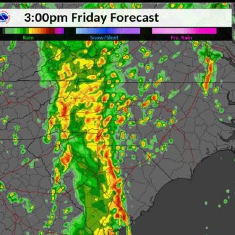
The National Weather Service in Raleigh said a batch of storm that moved across central North Carolina this morning have now moved into eastern North Carolina.
But additional storms are expected to develop this afternoon across the Triad in addition to a main squall line that will develop across the central North Carolina between 3 p.m. and 9 p.m.
This round of storms is expected to produce widespread downed tree and power outages and structural damages.
Tornadoes are possible.
GREENSBORO — A tornado watch has been issued for Guilford County until 5 p.m. Friday.
The National Weather Service in Raleigh said a severe thunderstorm is developing along and ahead of a powerful low pressure system that will impact central North Carolina.
The risk of significant severe weather has increased across central North Carolina and been upgraded to a moderate risk. Meteorologists said it has been more than 3 years since a moderate risk for severe storms has been issued in central North Carolina.
Friday’s storm is expected to being in the late morning and last through the evening. The storm could produce damaging wind gusts, flash flooding, tornadoes and hail.
Meteorologists said 60-75 mph winds are possible and 1-2 inches of rain. Due to recent heavy rains over the past week, streams are running high and soil is still wet posing a greater risk of flash flooding.
The storm also has potential to produce tornadoes with the potential for long-track tornadoes. Quarter-size or larger hail is also possible with this storm.